
A Project of the Guam Preservation Trust


Atantano Property Maps & Completed Research
The Guam Preservation Trust’s Atantano property is located between the villages of Piti and Santa Rita. The property incorporates two lot parcels: Lot 15 (325, 027+ sq. meters) and Lot 16 (372, 485+ sq. meters. The Atantano property is appraised as “underdevelop” for M-2 Heavy Industrial zoning.
Located east off of Route 2A towards the village of Agat, Atantano is surrounded by private and public properties. Geographically, the property is bounded to the east by Mount Tenjo and the Tenjo river in the northeast. The Paulana River meets the Atantano River in the southeast portion of the property, defining the Atantano River wetlands, which bisect the property.

Property description:
Lot No. 15 contains 325,027+ square meters
Lot No. 16 contains 372,485 + square meters
Zone: M-2 Heavy Industrial Undeveloped
North – low volcanic ridge trending into the EW with wide floodplains on each side
North East - abuts Tenjo River into a narrow wetland
East – Mt. Tenjo
South – Atantano River wetlands trending into the NW
Soil – Agfayan-Akina rock outcrop, Akina Badland Complex and Ylig clay
Click on a map below to magnify - Additional Maps found under the "Completed Research" section of this page.

Satellite Imagery

Baseline Information

LiDAR-Derived Bare Earth Model
Completed Research
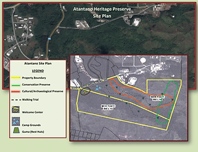
Proposed Site Plan

Trail in of March 2019
ENVIRONMENTAL
-
Archaeological Survey and Restoration of Damaged Latte Set (MARS)
-
Condition Assessment and Interpretive Plan for Atantåno Heritage Preserve.
MAPS
PHOTOS/VIDEOS
